Understanding Mount Rinjani: Size, Location, and Significance
Geographical Overview of Rinjani’s Position in Lombok
Located on the Indonesian island of Lombok, Mt. Rinjani is a majestic and imposing stratovolcano that rises prominently from the surrounding landscape. With an elevation of 3,726 meters (12,251 feet), it is the second highest volcano in Indonesia and a central feature of the island’s topography. The mountain is part of the Rinjani massif, which extends over a vast area within the Rinjani National Park, covering approximately 41,330 hectares. Its strategic position within the northern part of Lombok makes it a physical and cultural landmark, visible from many parts of the island.
The volcano’s positioning has historically influenced local climate patterns and ecosystems, creating a diverse habitat that ranges from tropical forests at lower altitudes to alpine environments near the summit. The surrounding region is characterized by lush greenery, fortified by abundant rainfall, and the volcanic slopes are dotted with hot springs, waterfalls, and fertile volcanic soil contributing to the island’s agricultural productivity.
Historical Eruptions and Volcanic Activity
Mt. Rinjani’s volcanic activity has been recorded for centuries, with its eruptions leaving a significant mark on Lombok’s history and landscape. Unlike many dormant volcanoes, Rinjani remains active, with the most recent notable eruption occurring in late 2015, which included ash plumes rising to 6 kilometers altitude and lava flows. Historically, eruptions have varied from mild lava flows and ash emissions to more violent events, impacting local communities and ecosystems.
The volcano’s activity is monitored closely by the Indonesian Volcanology Center, given its potential for future eruptions. These eruptions are generally classified as VEI-2 or VEI-3, which means they can cause ash fall and minor lava flows but rarely threaten large-scale destruction. Nonetheless, the risk of sudden activity underscores the importance of thorough preparedness and cautious planning for trekkers and local residents.
Significance within Taman Nasional Rinjani
The Mount Rinjani area is designated as a protected national park, Taman Nasional Gunung Rinjani. This status emphasizes both its ecological importance and its cultural significance. As one of Indonesia’s most prominent biodiversity hotspots, the park is home to numerous endemic species of flora and fauna, including the rare Rinjani hawk-eagle and various orchids. The park also plays a vital role in conservation efforts, safeguarding the complex ecosystems and geological features of the volcano.
Beyond its ecological value, Rinjani holds cultural and spiritual significance for local Sasak and Balinese communities. It is considered sacred, with traditional rituals and offerings performed at its slopes, especially near the crater lake, Segara Anak. This spiritual dimension enhances the mountain’s status as a symbol of natural and cultural heritage, attracting thousands of visitors annually for both adventure trekking and spiritual reflection.
Planning Your Rinjani Trek: Essentials and Tips
Necessary Equipment and Preparing for the Climb
Embarking on a trek to Mount Rinjani is an adventure that demands meticulous preparation. Due to the mountain’s elevation and unpredictable weather, proper gear is essential. Trekking poles can aid in stability and reduce joint stress, especially on steep descents. Warm, windproof clothing is crucial, as temperatures can drop significantly at higher elevations, sometimes below freezing.
A durable backpack, climbing gloves, headlamp, and sufficient high-energy food and water are also vital components of your packing list. Since many routes involve overnight camping, a high-quality tent and sleeping bag suitable for cold nights should be included. Footwear should be sturdy, waterproof, and well-broken-in to prevent blisters.
It’s advisable to carry a basic first aid kit, including supplies for altitude sickness, cuts, and insect bites. Hydration packs or water purification tablets can ensure safe drinking water along the trail. Research and preparation are the foundation of a safe trek, reducing the risk of unforeseen challenges.
Choosing Guides, Permits, and Safety Precautions
Navigating the Rinjani trails is best undertaken with professionally licensed guides and porters. Local guides possess invaluable knowledge of the terrain, weather patterns, and emergency procedures. A guide not only enhances safety but also enriches your cultural experience through sharing local stories and traditions.
Securing the necessary permits is mandatory before starting your trek—these can be arranged through authorized trekking operators or at the national park entrance. Failing to obtain the required documentation can result in legal complications or disqualification from certain routes.
Safety precautions include informing someone of your itinerary, carrying communication devices like a satellite phone or walkie-talkies, and knowing the location of park rangers and emergency facilities. Weather conditions can change rapidly—monitor updates daily and be prepared to adjust your plans accordingly.
Best Seasons and Optimal Timing for Trekking
The ideal trekking season for Mount Rinjani is during the dry season, which spans from April to October. These months typically offer clearer weather, reduced rainfall, and more stable conditions for climbing. The months of June to September are considered peak because of minimal rain and favorable temperatures.
The rainy season, from November to March, brings frequent showers, slippery trails, and increased volcanic activity risks. During this period, some routes may be temporarily closed for safety reasons. If trekking during the dry season, it’s wise to book accommodations and guides well in advance, as this is the most popular time for climbers.
Route Options and Trekking Experience
Sembalun vs. Senaru Routes: Which to Choose
The two main routes for ascending Mount Rinjani are the Sembalun and Senaru trails. Both approaches have unique characteristics and appeal to different types of trekkers. The Sembalun route, originating in the east, is known for its relatively easier ascent, gradual slopes, and expansive views of the crater rim. It starts at a higher altitude (around 1000 meters), offering better acclimatization opportunities.
Conversely, the Senaru route from the north involves a steeper ascent through lush forests and requires more physical effort. It is renowned for its scenic waterfalls and rich biodiversity. Trekkers choosing this path typically experience a more challenging climb but are rewarded with diverse landscapes and cultural encounters.
Duration, Difficulty, and Highlights of Each Path
The Sembalun route usually takes about two to three days to reach the summit and return, making it suitable for trekkers with moderate experience. Its highlights include the breathtaking crater rim views, the volcanic lakes, and the sunrise from the summit.
The Senaru route, often a three-day expedition, features dense forests, waterfalls such as Sendang Gila, and a more rugged terrain. The ascent is more demanding, but the journey offers a profound connection with nature, culminating in panoramic views from the summit’s crater.
Tips for Acclimatization and Managing Altitude
Altitude sickness can affect even experienced trekkers. To mitigate this, organize a gradual ascent—spending a night at intermediate altitudes can help acclimatize the body. Hydration is critical; drink plenty of water whether or not you feel thirsty.
Recognize early symptoms such as headaches, dizziness, or nausea, and descend if symptoms worsen. Maintain a steady pace, avoid overexertion, and listen to your guide’s advice. Taking amlodipine or other medications as prescribed by a healthcare professional can also reduce altitude-related risks.
Challenges and Risks of Climbing Mount Rinjani
Common Hazards and How to Avoid Them
Climbing Mount Rinjani entails certain inherent hazards. Volcanic eruptions, ash fall, and sudden weather changes pose significant risks. Slippery, rocky paths can cause falls, especially during rain or early morning dew. Altitude sickness and dehydration are also common.
To mitigate these dangers, always follow safety instructions, use appropriate gear, and stay informed about current volcanic activity. Trek with experienced guides who monitor conditions and can advise on safe routes. Avoid unnecessary risks like speeding through difficult sections or venturing alone.
Dealing with Unpredictable Weather and Volcanic Activity
Weather on Mount Rinjani can shift rapidly, with sudden rainstorms and fog reducing visibility and increasing hazards. Volcanic activity fluctuations require constant vigilance—ashes, gas emissions, or minor eruptions can occur unexpectedly.
Trekkers should carry weather-proof clothing, masks to cover nose and mouth during ash emissions, and consult real-time updates from park authorities. If signs of increased volcanic activity appear, including ash clouds or tremors, immediate evacuation is advised.
Necessary Emergency Preparedness
Despite careful planning, emergencies can happen. Carry an emergency communication device, know the location of the nearest rescue stations, and have a basic knowledge of first aid. In case of altitude sickness, dehydration, or injury, alert your guide immediately.
It’s recommended to have travel insurance that covers evacuation costs. Maintaining a calm attitude, staying in groups, and following safety protocols significantly enhance survival odds during unforeseen incidents.
Maximizing Your Rinjani Experience
Best Photos, Viewpoints, and Cultural Insights
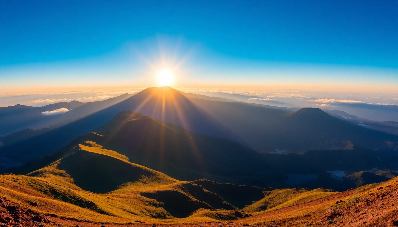
The summit of Rinjani offers some of Indonesia’s most stunning vistas—early morning light illuminates the crater lake, Segara Anak, with its shimmering blue waters contrasted against the black volcanic landscape. Sunrise from the rim is a photographer’s paradise, capturing the vast basin and surrounding mountain ranges.
Other noteworthy viewpoints include the crater rim, Torean Valley, and hot springs near the base. These sites provide exceptional opportunities for photography and reflection. Interacting with local communities in the villages along the trails reveals rich cultural traditions, folklore, and rituals, enriching the overall trekking experience.
Environmental Responsibility and Conservation Tips
As a treasured natural site, it is crucial to practice Leave No Trace principles. Pack out all trash, minimize campfire impacts, and stay on designated trails to protect fragile ecosystems. Avoid disturbing wildlife and refrain from collecting plants or rocks.
Supporting local communities by purchasing handmade crafts and participating in eco-tourism initiatives fosters sustainable tourism. Education about the park’s significance and respecting local customs ensures Rinjani’s preservation for future generations.
Post-trek Tips: Health, Souvenirs, and Sharing Your Story
After completing your trek, prioritize hydration and proper rest to recover from physical exertion. Share your journey and insights with friends and online platforms to raise awareness of Lombok’s natural beauty and conservation needs.
Consider purchasing locally made souvenirs, such as woven fabrics or handcrafted jewelry, to support artisans. Remember to leave positive feedback for your guides and service providers, encouraging sustainable and respectful trekking practices.
